Japanese Government Gifts Minecraft Players Free Map of Iconic Underground Tokyo
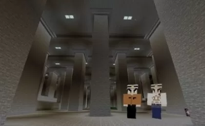
The Japanese government has unveiled a fascinating Minecraft map featuring the world's largest underground flood prevention facility, allowing players to explore one of Tokyo's hidden gems from the comfort of their own homes. This map, which can be downloaded for free, showcases the Metropolitan Area Outer Underground Discharge Channel, affectionately known as G-Cans.
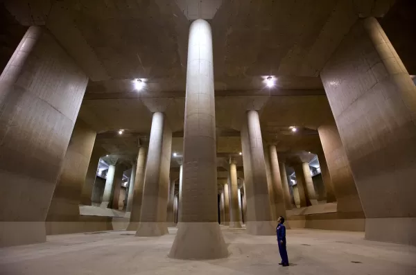
G-Cans is not just a practical disaster prevention facility; it's also a visually striking location, renowned for its "pressure adjustment water tank." This awe-inspiring space, adorned with 59 massive pillars, resembles an underground temple—aptly nicknamed "chika shinden" in Japan. Its dramatic ambiance has made it a popular backdrop for music videos, Japanese TV dramas such as Kamen Rider, and even movies.
While tours of G-Cans are available during dry seasons, the Japanese Ministry of Land, Infrastructure, Transport and Tourism (MLIT) has now brought this remarkable facility into the digital realm of Minecraft. The ministry has shared a video on their official YouTube channel that not only explains the purpose of G-Cans but also provides a glimpse into its Minecraft representation.
The Minecraft G-Cans map is more than just a replication of the facility; it also includes an overground area complete with rivers, homes, and neighborhoods. This design helps players understand how G-Cans protects real-life communities. Additionally, players can step into the control room and simulate draining flood water into the shafts, offering an interactive way to learn about its operations.
MLIT’s Minecraft recreation of G-Cans is intended as an educational tool, illustrating the facility's role in disaster prevention and highlighting its immense scale. In reality, G-Cans features over 6km of concrete tunnels beneath Saitama Prefecture in the Greater Tokyo Area. Its five shafts are crucial during Japan's rainy and typhoon seasons, capturing water from flood-prone rivers and gradually releasing it into the larger Edogawa River and Tokyo Bay. Since its completion in 2006 after over a decade of construction, G-Cans has been instrumental in mitigating flooding in the region.
You can download the G-Cans Minecraft map for free from the official website of the Edogawa River Office, which oversees the facility. To explore this digital marvel, ensure you have at least Version 1.21.1 of Minecraft Bedrock Edition or Version 1.21.0 of Minecraft Education Edition installed.


-
1
![Roblox Forsaken Characters Tier List [UPDATED] (2025)](https://imgs.ksjha.com/uploads/18/17380116246797f3e8a8a39.jpg)
Roblox Forsaken Characters Tier List [UPDATED] (2025)
Mar 17,2025
-
2
Roblox UGC Limited Codes Unveiled for January 2025
Jan 06,2025
-
3
Stardew Valley: A Complete Guide To Enchantments & Weapon Forging
Jan 07,2025
-
4
Pokémon TCG Pocket: Troubleshooting Error 102 Resolved
Jan 08,2025
-
5

Free Fire Characters 2025: Ultimate Guide
Feb 20,2025
-
6
Blood Strike - All Working Redeem Codes January 2025
Jan 08,2025
-
7
Roblox: RIVALS Codes (January 2025)
Jan 07,2025
-
8

Blue Archive Unveils Cyber New Year March Event
Dec 19,2024
-
9
Delta Force: A Complete Guide to All Campaign Missions
Apr 09,2025
-
10

Cyber Quest: Engage in Captivating Card Battles on Android
Dec 19,2024
-
Download

A Simple Life with My Unobtrusive Sister
Casual / 392.30M
Update: Mar 27,2025
-
Download
![Corrupting the Universe [v3.0]](https://imgs.ksjha.com/uploads/66/1719514653667db61d741e9.jpg)
Corrupting the Universe [v3.0]
Casual / 486.00M
Update: Dec 17,2024
-
Download

Ben 10 A day with Gwen
Casual / 47.41M
Update: Feb 24,2025
-
4
Random fap scene
-
5
Oniga Town of the Dead
-
6
Cute Reapers in my Room Android
-
7
A Wife And Mother
-
8
Permit Deny
-
9
My School Is A Harem
-
10
Utouto Suyasuya