This GPS Map Camera app seamlessly integrates camera functions with precise GPS location tracking. Its features, including geotagging, GPS scanning, and GPS mapping, create a visual journey log. The app's robust mapping system lets users view their photos geographically, and it even adds location data to existing images. Whether you're a seasoned photographer or a casual picture-taker, this app makes adding geolocation to your photos incredibly easy and intuitive. It's designed for seamless use with GPS-enabled devices.
The GPS Map Camera App boasts six key advantages:
-
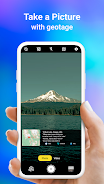
Integrated Camera and GPS: Capture photos and instantly geotagging them with precise location data, creating a visual travel diary.
-
Versatile Photo Capture and Tracking: Use the built-in GPS camera or add location data to existing photos afterwards.
-
Powerful Mapping System: Easily visualize your photos on an interactive GPS map, showing their location relative to your journey.
-
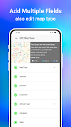
Customizable Date and Time Stamps: Add date and time stamps to your photos in your preferred format.
-
Customizable Photo Management: Save photos with custom names and enjoy live navigation for easy organization.
-
Lightweight Option Available: A Lite version provides many core features while minimizing device storage usage.


v1.1.6
5.00M
Android 5.1 or later
com.locationonphoto.gpsmapcamera.geotagging.gpscam