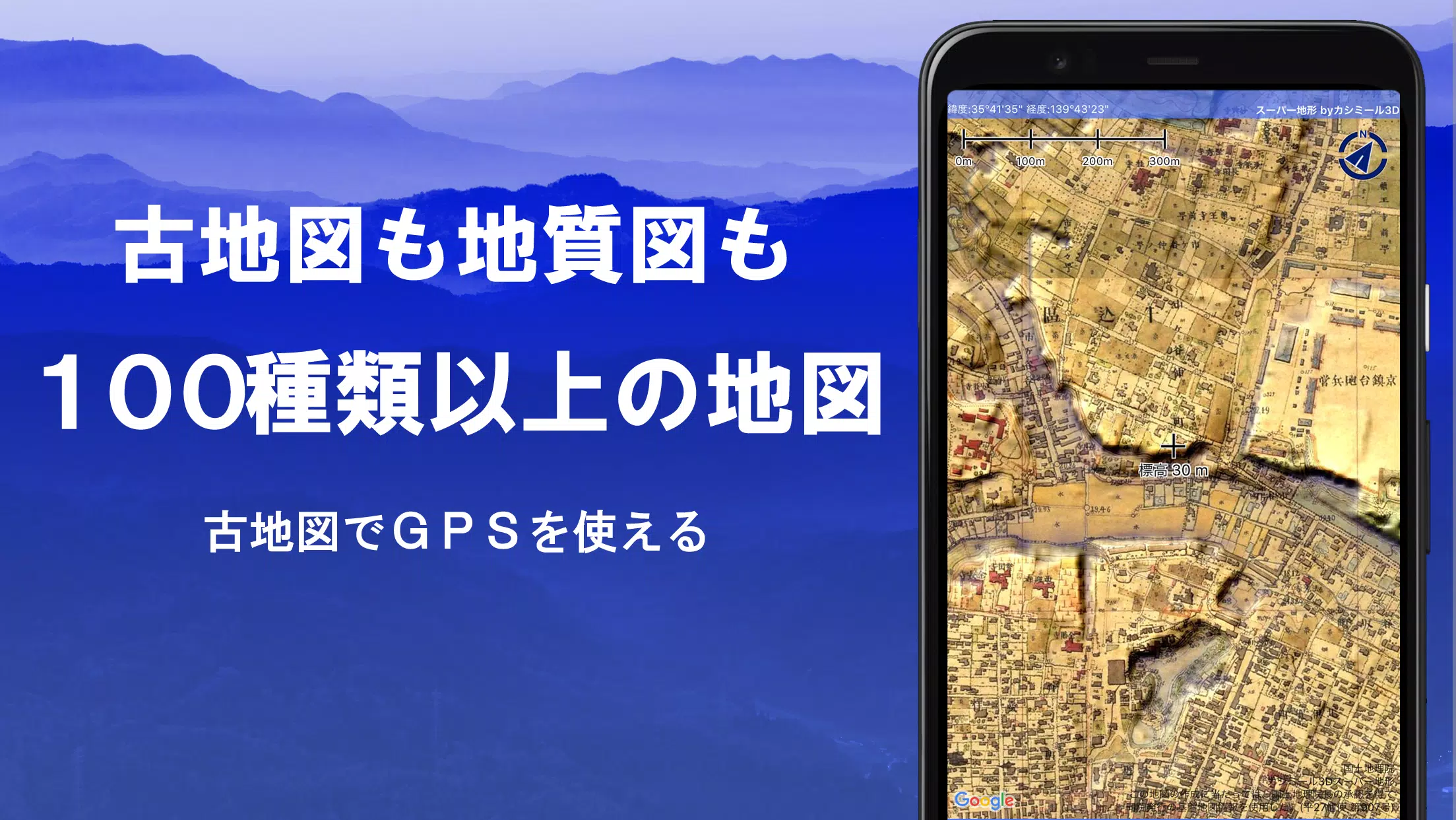
Discover a world of exploration with over 100 types of maps at your fingertips, including the detailed Geographical Survey Institute map. Whether you're scaling mountains or strolling through town, these maps help you leverage the terrain to enhance your outdoor experience. Our app received the prestigious 2018 Japan Cartographic Society Award for Best Work, a testament to its quality and utility.
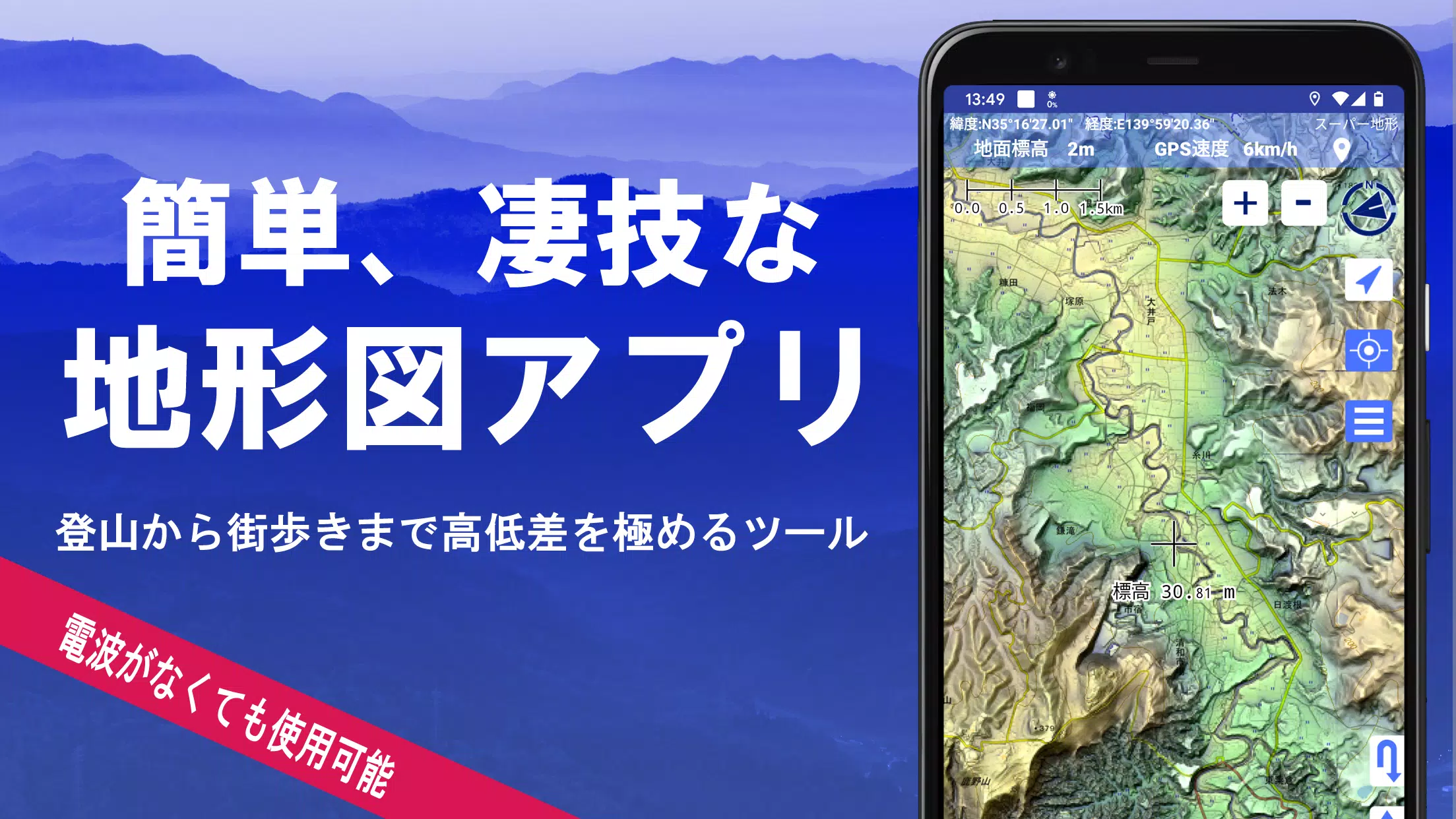
Experience the power of "super terrain data," which brings the landscape to life through our unique technology. Alongside, utilize a wide array of maps from the Geospatial Information Authority of Japan, including topographic, geological, historical, and even prewar Ordnance Survey Department maps. With the built-in GPS function, you can record your tracks, import/export GPX logs, and edit them seamlessly. Enhance your adventures with features tailored for urban exploration, mountain climbing, and various outdoor activities, such as GPS navigation with audio cues and robust data recording and editing tools.
Our app includes a visibility determination function, perfect for creating cross-sectional diagrams, observing landscapes, and assessing radio signal paths, with the added capability to display buildings. Enjoy a 360° panoramic view that identifies mountains by name, and see the sun, moon, and your GPS points. Utilize the offline map cache function for uninterrupted use in areas without radio signals, ensuring smooth operation during your outdoor escapades. You can also associate photos with specific points, display contour lines from elevation data, and overlay MGRS grids. Additionally, the app supports reading, displaying, and editing GIS data from GeoJSON files, drawing shapes, and works seamlessly overseas. For your convenience, map printing and PDF output are available, and the app supports a dark theme for easy viewing in various lighting conditions.
A Wealth of Maps at Your Disposal
Explore a variety of maps, including over 100 types, such as our proprietary super topographic data and maps from the Geospatial Information Authority of Japan, including hazard maps. Note that aerial photographs may vary by age group, with "latest" and "around 1974" providing broader coverage. Enjoy a free 5-day trial of maps using super terrain data after installing the app.
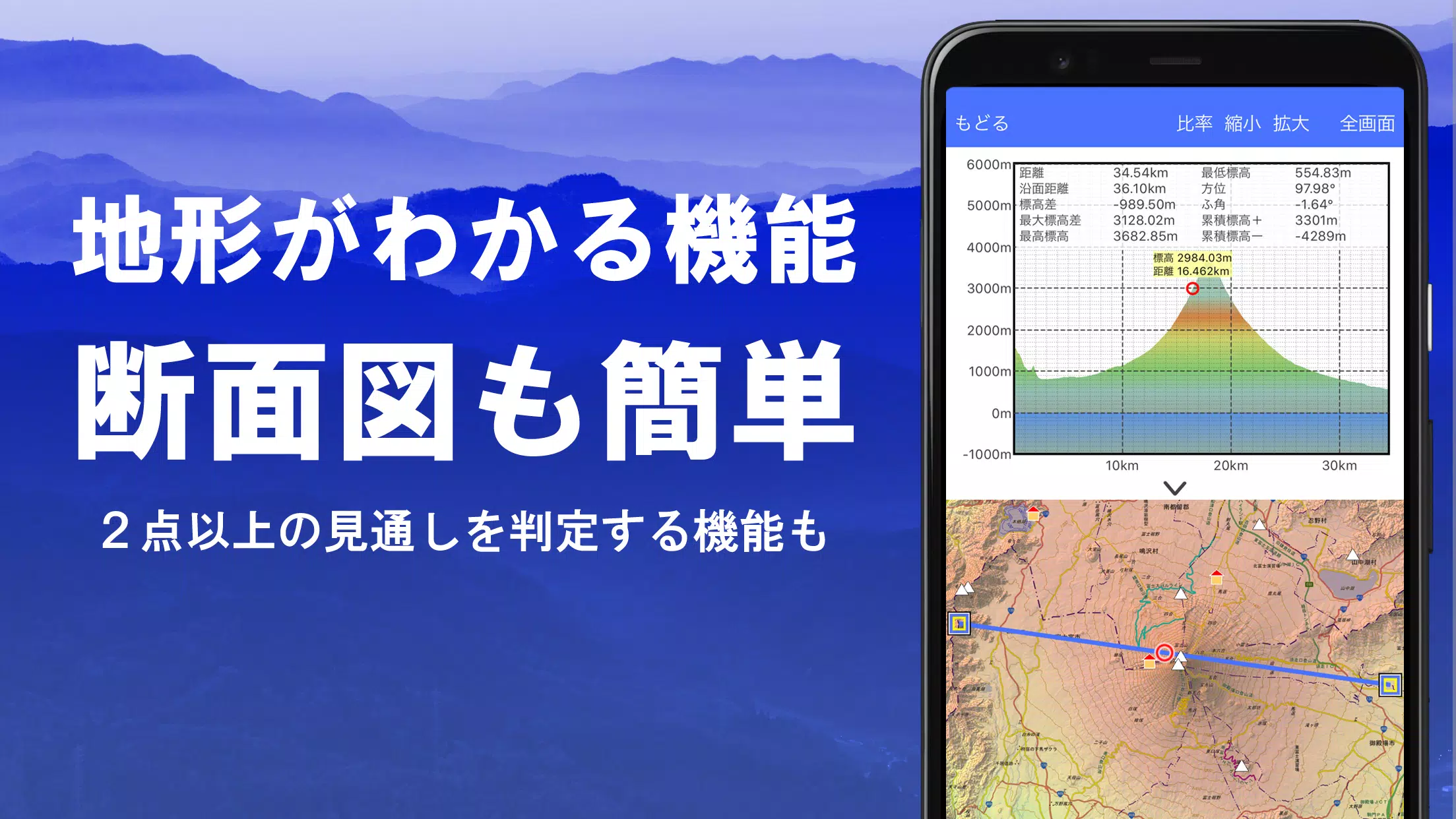
Cross-Sectional and Outlook Creation
Effortlessly draw cross-sections through any point on the map. The app features a visibility judgment function, familiar from Kashmir 3D, which accounts for Earth's curvature and atmospheric variations. This tool is invaluable for route planning during mountain climbing, assessing wireless visibility, and understanding terrain. Where PLATEAU building data is available, you can incorporate buildings into your cross-sectional views.
Elevation Palette Function
Customize your map's appearance with the elevation palette function, allowing you to change the map background color in 1cm increments to suit your preferences.
Panoramic View
Experience panoramic observation maps that identify mountains from any location on the map. Utilize a 360° panorama linked to your smartphone's compass for precise mountain identification. View the sun and moon, including moon phases, to plan sightings like Diamond Fuji and Pearl Fuji. Display GPS points and explore panoramic views of mountains abroad.
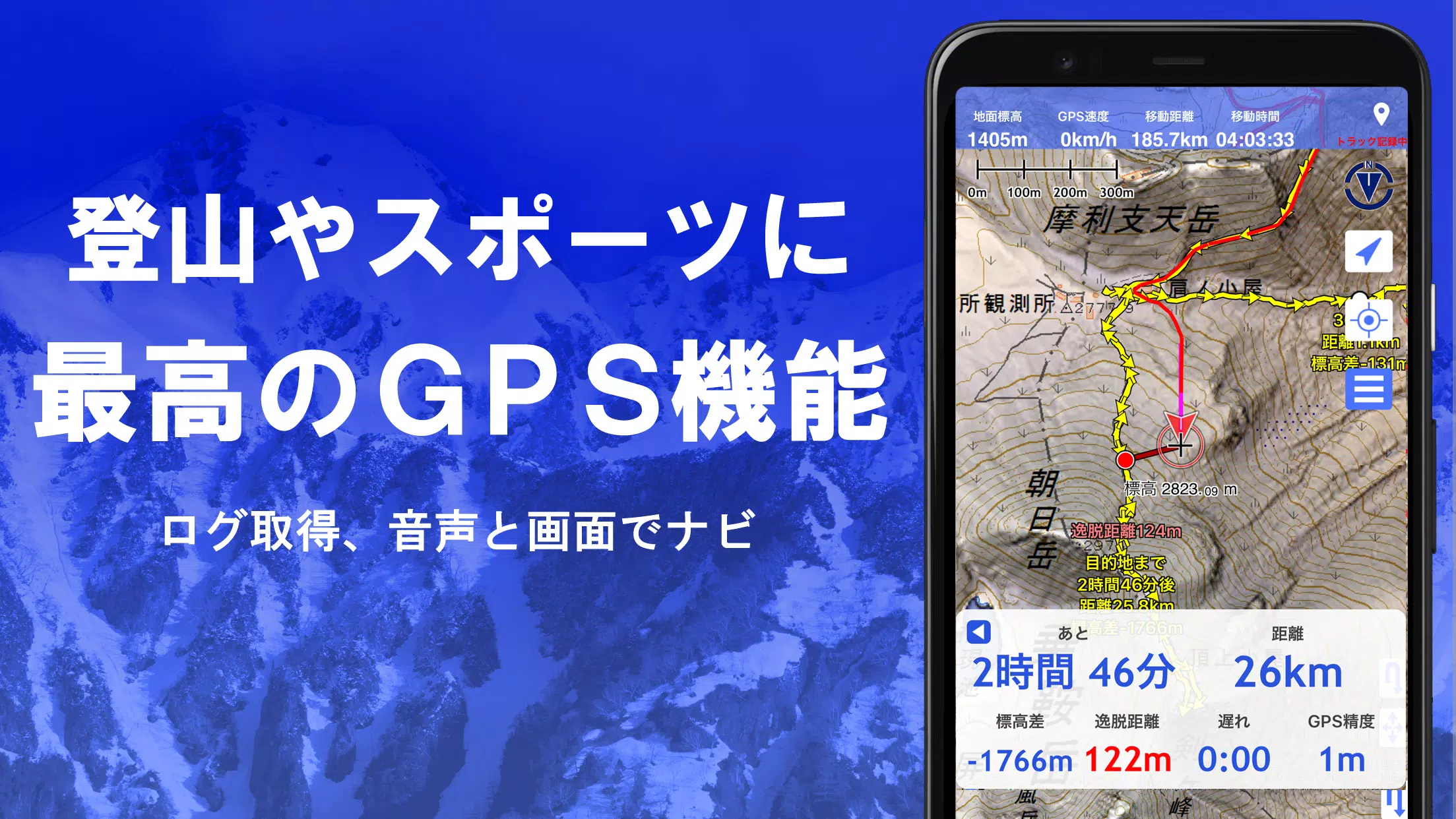
GPS Functionality
Leverage your smartphone's GPS to obtain location data and record your tracks. Our app employs high-precision positioning suitable for serious mountain climbing and outdoor activities. Visualize your recorded tracks with parameters like elevation gain, speed, time, and elapsed time. The point alarm function alerts you with voice and sound cues when approaching designated points. Display photos linked to specific locations and send the map center position to NaviCon.
GPS Track Summary Playback
Replay your tracks in summary mode, which automatically displays photos from your smartphone based on their timestamps. Icons appear at photo locations, allowing you to view them with a tap.
GPS Navigation
Navigate along predefined tracks using the Track Navi function, with voice or alarm alerts if you deviate from the path, ensuring you stay on course during your climbs. Additionally, utilize route navigation for urban walks and point navigation to reach specific destinations.
GPS Data Editing
Manage GPS-related points, routes, and tracks efficiently with folder organization and a user-friendly tree format. Create tracks directly on the map, and import/export them in GPX format from various mountain climbing sites.
Offline Map Usage
Access maps even in areas without a signal, thanks to the bulk download function, which lets you download all scale maps for a specified area. Monitor download progress to ensure you have the maps you need on-site. A cache function is also available for offline use.
Map History Function
The app remembers your previous locations, allowing you to quickly return to areas you've explored before.
Custom Map Compatibility
Import and use custom maps created with Kashmir 3D's map cutter, including your own maps and scanned images. When using the map cutter, split images into approximately 256 x 256 segments and send the resulting kmz file to Super Terrain via email or Cloud Drive.
GeoJSON Compatibility
Display and edit points, linestrings, and polygons from GeoJSON files, and draw new shapes within the app.
Print and PDF Output
Print any map area at a specified scale or generate a PDF for your records.
App Integration
Import and export GPS data in GPX, KML, and GDB formats, enabling seamless data exchange with other apps, PC software like Kashmir 3D, and mountain climbing sites.
Backup Function
Safeguard your data by backing up all app content (excluding cached maps) and storing it off your smartphone. Restore your data even if the app is deleted or your device malfunctions. An automatic backup feature using Google Drive ensures your data is always up-to-date. Refer to the manual for detailed instructions.
Billing Information
Certain functions, such as maps using super terrain data, GPS track features, and cross-sectional views, require in-app purchases. After payment, you'll enjoy an increased number of search results for place name searches.
- Fees: Annual payment of 780 yen/year.
- Free Trial: Use the app for free for 5 days after installation. Post-trial, some features and maps will be unavailable unless you purchase them.
- Confirmation and Cancellation: Check and manage automatic updates through Google Play under "Regular Purchase" and select "Super Terrain."
- Price Revision: Future feature enhancements may lead to price revisions. Early purchase offers the best value.
Terms of Use
The copyright holder and developer are not responsible for the outcomes of using this app. Upon first use of GPS, you'll be prompted to allow location services. Be aware that continuous GPS use can drain your battery, so consider carrying a spare if your device is used for emergency communication. For detailed navigation instructions, refer to the PDF at https://www.kashmir3d.com/online/superdemapp/superdem_navi.pdf. Some smartphones may experience interruptions in track recording due to power-saving features, a common issue across various apps. Turning off the screen while using the app may prolong recording, but it's not a permanent solution.
4.6.17
16.7 MB
Android 5.0+
com.kashmir3d.superdem