Application Description:
For adventurers and hikers, Altimeter GPS is the ultimate elevation tracking app. Easily monitor your altitude and precise location above sea level. This comprehensive app includes a compass altimeter and elevation map, eliminating the risk of getting lost. Share your location with others for enhanced safety. Features include walking modes, a barometer for atmospheric pressure readings, and real-time weather updates (humidity, wind speed, visibility). Elevate your hiking experience with Altimeter GPS. Download today and explore!
Key Features of Altimeter GPS:
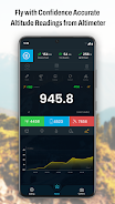
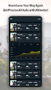
- Precise Altitude Measurement: Accurately track your elevation above sea level during hikes and travels.
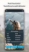
- Integrated Compass Altimeter: Navigate with confidence using the built-in compass and altimeter.
- Interactive Elevation Map: Visualize your elevation on a map for clear situational awareness.
- Reliable Offline Tracking: Leveraging advanced barometric pressure technology, track your altitude online or offline, even in remote areas with limited connectivity.
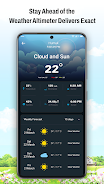
- Comprehensive Weather Data: Access real-time weather information: humidity, air pressure, wind speed, temperature, and visibility.
- Trip History & Flashlight: Review past hikes and easily resume your journey from any saved point. A built-in flashlight ensures usability in low-light conditions.
In Conclusion:
Altimeter GPS is a must-have tool for hikers and outdoor enthusiasts who need precise altitude and location tracking. With its accurate altitude meter, compass, elevation map, offline capabilities, weather updates, and trip history, this app provides everything for a safe and enjoyable outdoor adventure. Whether you're a seasoned hiker or just starting out, Altimeter GPS will enhance your excursions and provide peace of mind. Download Altimeter GPS now and unlock a new level of exploration!
Screenshot
App Information
Version:
1.3.6
Size:
14.00M
OS:
Android 5.1 or later
Developer:
CloudWest Technology
Package Name
com.smart.gps.altimeter.altitude.elevation.app
Reviews
Post Comments


Trending apps


Software Ranking